
Council Approves Updated Official Plan and Complete Communities Secondary Plan


 Back to Search
East Gwillimbury (EG) is taking a major step toward its future as Council adopted the Town's updated Official Plan (OP), including the Complete Communities Secondary Plan (CCSP) at the July 23, 2026, Council meeting. The OP establishes a roadmap for growth and community building and a comprehensive framework to guide growth, infrastructure, housing, environmental protection, and community facilities through to 2051.
The updated OP provides a long-term vision for how EG will evolve as a balanced and complete community while protecting the natural and agricultural assets that make EG unique. By 2051, EG is projected to grow to a population of approximately 128,600 residents and support 44,300 jobs. The OP outlines how growth will be accommodated through a range of housing options, employment opportunities, public service facilities, commercial uses, transportation networks, and municipal infrastructure.
“The Official Plan is about building the East Gwillimbury we want future generations to call home,” said Mayor Virginia Hackson. “Shaped by years of collaboration and community input, the Official Plan balances growth with environmental stewardship, supports housing and economic opportunities, and preserves the character that makes our town unique. Thank you to everyone who helped create this vision for East Gwillimbury's future.”
At its core, the OP is guided by several key principles, including:
- Protecting and enhancing the natural heritage system;
- Supporting a vibrant agricultural and rural community;
- Creating complete communities through thoughtful development;
- Encouraging a diverse range of housing options;
- Promoting sustainable and fiscally responsible growth;
- Supporting climate resilience and environmental stewardship; and
- Creating opportunities for long-term economic prosperity.
Inclusion of Complete Communities Secondary Plan
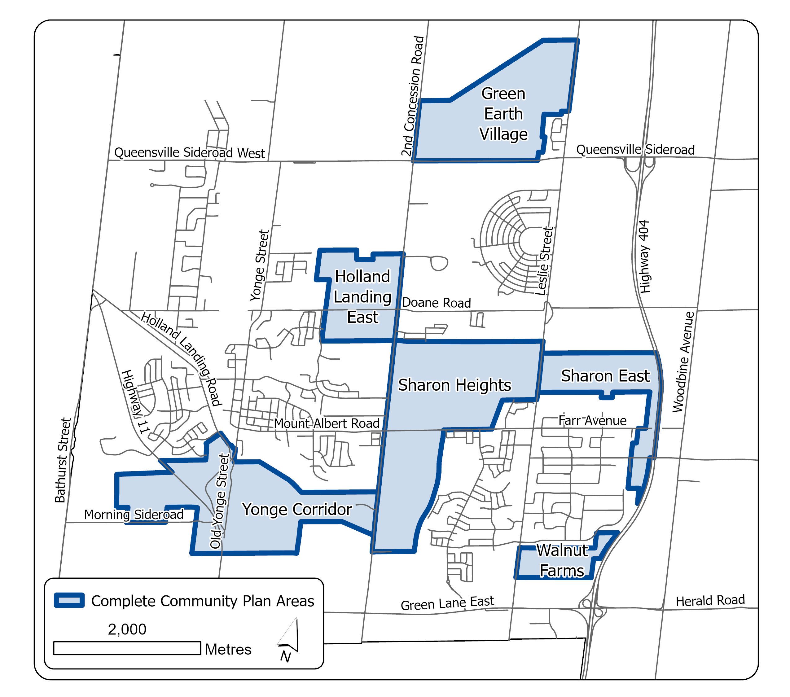
A key component of the OP is the integration of the Complete Communities Secondary Plan, first introduced in 2023. The CCSP establishes a planning framework for six areas that have been identified for growth:
- Green Earth Village
- Holland Landing East
- Sharon Heights
- Yonge Corridor
- Walnut Farms
- Sharon East
The CCSP creates a vision for future neighbourhoods by identifying housing, commercial and employment areas, while also planning for parks, schools, community centres, and other amenities needed to support complete communities. The framework will guide future Community Design Plans, zoning updates, and other planning initiatives.
Background
The OP Review began in 2020 and included extensive engagement with residents, landowners, agencies, and government partners. The Williams Treaties First Nations were also meaningfully consulted as Treaty Rights-Holders. Their feedback ensured that the OP identifies that consultation with Treaty Rights-Holders must occur when land planning processes impact Treaty Rights.
Following Council's initial adoption of the Official Plan in 2022, Town staff worked closely with York Region and the Ministry of Municipal Affairs and Housing to ensure conformity with regional and provincial planning policies. The Council adopted Plan reflects this collaboration as well as public feedback received throughout the process.
As EG looks toward the future, the updated Official Plan provides a strong foundation for managing growth, creating complete communities, protecting valuable natural and agricultural resources, and maintaining the high quality of life residents enjoy today.
Next Steps
The Official Plan will be submitted to the Ministry of Municipal Affairs and Housing for review and approval in accordance with the Planning Act.
To learn more and view the 2026 Official Plan and Complete Communities Secondary Plan, visit eastgwillimbury.ca/officialplan and eastgwillimbury.ca/ccsp.
 Subscribe
Contact Us
Our Customer Service Team is here to help!


